2024
2025
December 18, 2023

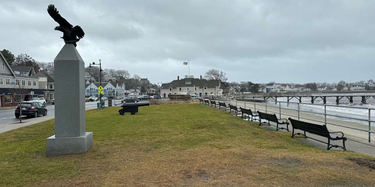
Fisherman's Beach
Managed by Swampscott Conservancy
Since 2023
In Massachusetts, US
SCC201
This chronolog combines 42 photos from 16 contributors. Learn more
About this site
This Chronolog station is hosted by the Swampscott Conservancy in collaboration with the Town of Swampscott. The focus of this station centers on our coast, the Swampscott Fish House, and the Albert J. Williams Town Pier (constructed in 1961). The Swampscott Fish House, built in 1896, is a registered national landmark, and the oldest municipally owned working fish house in the country.
As more and more photos are added, we'll be able to collectively view how the shoreline is impacted by those seasonal ”wicked” high tides (aka “King tides”) as well as storm surge. Swampscott experiences an average tidal change of about 8 ft. During King tides and certain storm events high tides can be 2-4 ft. higher than normal. When these occur flooding can extend past the traffic light at the intersection of Puritan Road and Humphrey Street, submerge the pier, and reshape our coastline. These high tides provide our community with a window into how sea level rise will soon start affecting our daily lives. As our town plans for the impacts of climate change though implementation of the 2023 Resilient Swampscott Climate Action & Resilience Plan, photos like yours will help understanding
The town has started to take steps, such as the plantings in the pathway between Chaisson Park and the Fish House parking lot that will help mitigate storm surge. These plantings included non-native lyme grass (Leymus arenarius) and an non-native beach rose (Rosa rugosa) which serve to slow the flow of water through this area, a nature-based solution to the impacts of climate change. Ideally future plantings will include native species which will improve both resilience and provide habitat for our native coastal biodiversity.
Swampscott's Harbor at Fisherman's beach is home to one of the significant eelgrass beds found on the northshore. Eelgrass (Zostera marina) forms a valuable shallow-water coastal habitat that provides important ecosystem benefits including carbon storage. Since state eelgrass bed monitoring began in the late 1990s, the eelgrass bed at Fisherman's beach has shown significant growth as it bounced back after a dredging project was conducted in 1993. This growing bed helps to protect the harbor from climate change by absorbing wave energy and providing additional protection from storm surge, reducing coastal erosion by stabilizing sediment with their roots, reducing ocean acidification by absorbing CO2, and absorbing excess nutrients and pollution in the harbor.
Thank you for submitting your image to this photo station! Your photographs help our community understand how the shoreline in Swampscott is changing.
Find out more about our other education initiatives and get involved at https:www.swampscottconservancy.org.
About Swampscott Conservancy
The mission of The Swampscott Conservancy, a 501(c)(3) nonprofit organization founded in 2018, is as follows:
“To protect and enhance Swampscott’s natural resources for the benefit and enjoyment of the public by: increasing awareness of, and ensuring access to, the Town of Swampscott’s public natural open spaces; collaborating with Town of Swampscott committees, boards, commissions, departments, and non-profit entities, in maintaining and improving public natural areas; engaging in educational activities including events and campaigns to increase public awareness and appreciation of natural open space; to act as an advocate and spokesperson for open space preservation.”
For nature-lovers
Explore chronologs
For organizations
Chronolog is a monitoring tool for parks, nature centers, wildlife organizations, schools, and museums worldwide. With over 100,000 contributors across 300 organizations, Chronolog is on a mission to engage communities with nature while recording important natural changes.
© Chronolog 2025 | Terms